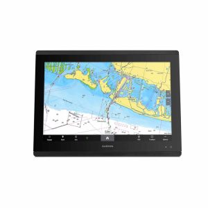
GPSMAP 8422 is a 22-inch marine chartplotter and multifunction display designed to give you a powerful, networked helm station with navigation, connectivity, and system control all in one unit. It comes with a Worldwide Basemap for broad map reference right out of the box.
Display & Design
-
Large 22″ Full HD touchscreen display (1920 × 1080) with anti-glare finish — easy to see even in bright sunlight.
-
IPS screen technology gives consistent colours and wide viewing angles.
-
Install multiple units edge-to-edge for a sleek “glass helm” look.
-
Can be mounted flush or flat depending on your helm setup.
-
Water rating: IPX7, meaning it’s protected against splashes and rain.
Navigation & Mapping
-
Worldwide Basemap pre-installed — basic map data showing coastlines, land and sea outlines, and relevant reference info.
-
Can accept premium marine charts like BlueChart G3, Navionics+ and Vision+ for more detailed navigation data (sold separately).
-
Waypoints: up to 5 000.
-
Routes: up to 100 (each with up to 250 waypoints).
-
Track log memory: stores up to 50 000 points with 50 saved tracks.
Navigation & Connectivity
-
10 Hz high-sensitivity GPS receiver: updates position and heading 10 times per second.
-
NMEA 2000 and NMEA 0183 compatible for integrating autopilots, engine data, sensors, and more.
-
Garmin Marine Network™ ports: connect to radar, sonar modules, cameras, other displays, and network gear.
-
Wireless: built-in Wi-Fi plus Bluetooth/ANT for connections with mobile apps and accessories.
Advanced Features
-
SmartMode™ control — customizable presets for different activities (fishing, docking, etc.).
-
Supports sonar integration with external modules (Black Box sonar, Panoptix, LiveScope, etc.).
-
AIS (Automatic Identification System) and DSC (Digital Selective Calling) support when connected to compatible VHF systems.
-
Fusion-Link audio system support, networked media control, and camera support.
-
ActiveCaptain® app compatible — gives planning tools, updates, and notifications via smartphone.
Physical & Electrical Specs
-
Dimensions: ~20.8″ × 13.8″ × 2.8″ (52.8 cm × 35.1 cm × 7.1 cm).
-
Weight: ~15.6 lb (7.09 kg).
-
Power: operates on 10–35 V DC with typical draw ~3.9 A at 12 V.
-
Waterproof construction (IPX7).
What’s in the Box
Typical kit includes:
✔ GPSMAP 8422 unit
✔ GPS 19x NMEA 2000 antenna
✔ Protective cover
✔ Mounting hardware
✔ Cables and NMEA 2000 backbone kit
✔ Documentation.
Expandability
This MFD works best as part of a larger marine system — you can add radar, multiple sonars, autopilot, sensors, cameras, digital switching and more to build a fully integrated helm station.